


The National Weather Service has been downgraded Hurricane Irma to a tropical storm.
Even with the downgrade the storm has still caused problems for Florida residents including power outages, fuel shortages, down power lines, fallen trees, and standing water.
The downgrade does not mean that those in the path of the storm are out of the woods yet. Irma is still dangerous and damage is expected.
PREVIOUS:
The National Weather Service has announced that Hurricane Irma is still a Category 5 storm and is headed for Florida in the coming days.
Right now the storm is north of the Dominican Republic and is headed northwest into Florida. It is expected to make landfall in Florida by late Saturday night, early Sunday morning.
At this time meteorologists aren’t sure if the storm will be downgraded by the time it hits the U.S. coast, but they do predict it will stay between a Category 4 and 5 storm.
Currently, it is too soon to tell what direction the storm will go once it makes landfall but it seems to be heading up the coast through Georgia and South Carolina.
PREVIOUS:
Meteorologist Thomas Wineset with the National Weather Service in Jackson said that the storms winds are reaching 175 miles per hour, and it is moving west at 14 mph.
“The storm is located just east of the Antilles and southeast slightly of Puerto Rico,” said Winset. “The forecast track takes Irma past the northeast coast of Puerto Rico, through the Bahamas, and kind of off the northeast coast of Cuba. That is kind of where the uncertainty starts to increase.”
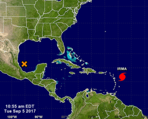
He said they cant rule out the potential for Irma to come into the east portion of the Gulf of Mexico, but how far west Irma tracks before turning north will be key to whether or not Mississippi will be impacted.
Wineset said hopefully by Wednesday or Thursday they should have a better idea of where the storm is going.
Stay tuned for updates.