Federal authorities have given the green light for plans to boost the visitor experience at Shiloh National Military Park’s Corinth location to move forward.
The National Park Service announced that after finalizing new land development concepts and environmental assessment plans, a proposal to provide management guidance for new lands added to the National Military Park since 2000 can continue without further review.

Under the plan, when entering the parking lots at the Corinth extension, visitors will encounter interpretive media clearly identifying the area as a national park and a component of Shiloh National Military Park. The signage would also provide information about the resources in the unit and their relationship to the wider Civil War history and timeline of events surrounding the Battle of Shiloh, along with the siege, battle, and occupation of Corinth.
Visitors will have the chance to experience the main attractions of the park by means of a minimal but accessible trail network that, at some sites, aims to provide recreational pedestrian hiking opportunities. Over time, some areas will be restored to vegetation schemes more fitting of the park’s period of significance through the use of manual thinning and prescribed fire.
“The plan/EA provides long-term guidance for public access and preservation of recently added siege and battle sites,” a statement from the National Park Service reads. “The plan outlines an approach for landscape restoration and development of visitor infrastructure at battlefield sites; it integrates natural and cultural resource protection goals of the park and assesses impacts related to visitor experience.”
Background
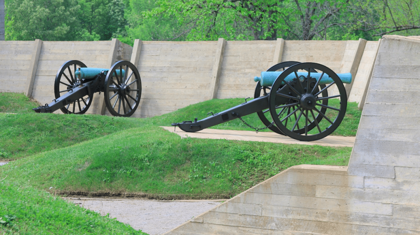
The park was established in 1894 to preserve the scene of the first major battle in the western theater of the Civil War. Until 2000, the park contained about 3,900 acres of the Shiloh Battlefield and the Shiloh National Cemetery in southwestern Tennessee, and the land around Battery Robinett in Corinth.
The Corinth Battlefield Preservation Act of 2000 significantly expanded the park’s boundary by creating the Corinth Battlefield Unit of the park. The boundary was again extended on December 26, 2007, and again in 2019, bringing the total authorized acreage of Shiloh National Military Park to approximately 9,743 acres.
Currently, just over 6,976 acres of the park’s authorized boundary are under National Park Service management, with about 5,268 at the Shiloh Battlefield Unit, approximately 861 acres at the Corinth Battlefield Unit, and approximately 847 acres at the Davis Bridge Battlefield Unit in Tennessee.
Other Improvements Being Made
Across all newly-acquired lands, the park will continue to highlight the ranks of soldiers and battle locations through physical markers at the Shiloh Battlefield Unit. Improvements will also be made in areas of the park where the National Park Service has already established visitor services.
The Battery Robinett subunit will continue to serve as the primary and initial visitor contact location and administrative hub for the Corinth Battlefield and the Davis Bridge Battlefield Units. It will continue to be the only subunit with full-time National Park Service staff.
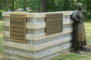
Restoration projects on recently or soon-to-be-acquired properties will be done off the park’s landscape to make the park more aesthetically pleasing. At the Contraband Camp subunit, improvements will include reconfiguration of the parking lot and entrance to better serve buses, while also branding the site as part of the National Park Service.
Interpretation enhancements will come by establishing additional waysides and a recreational hiking experience in a natural setting.