


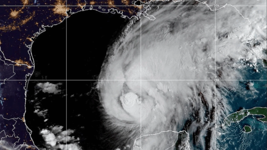
Isaias strengthened into the first hurricane of the Atlantic season late Wednesday as it surges towards the Gulf Coast, the National Hurricane Center said.
NHC classified Isaias as a Category 1 hurricane, and although the storm has shifted its trajectory to the east, it is still expected to make landfall late Friday night or early Saturday morning. NHC also updated its tropical storm and hurricane watches and warnings for parts of southern Mississippi.

As of 4 a.m. on Thursday, Wayne, Perry, and Stone counties were under a tropical storm watch, while Hancock, Harrison, George, and Green counties were facing greater risk and placed under a tropical storm warning. Jackson County is the only one in the Magnolia State under a hurricane warning.
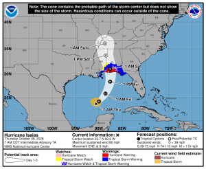
According to the NHC, storm surge warnings remain in effect on the entire Mississippi Gulf Coast. Isaias is expected to bring heavy rainfall, powerful winds, and flooding to parts of southern Mississippi.
“Damaging hurricane force-winds are expected over portions of the Florida Panhandle, southern Alabama, and southern Mississippi, and hurricane warning remains in effect from Ocean Springs, Miss. to the Bay/Gulf County Line, Fla.,” the NHC wrote in an update. “Residents in these areas should prepare for the possibility of long-duration power outages.”
The Mississippi Emergency Management Agency (MEMA) is urging residents on the Coast to begin preparing for the storm and to monitor the weather as Isaias could strengthen into a Category 2 hurricane.
“The threat is real, and now is the time to prepare,” MEMA Executive Director Stephen McCraney said. “We have seen how quickly tropical systems can impact Mississippi. Tropical Storm Arthur in June brought tremendous amounts of rain, flash flooding, and significant damage. You should not wait until the last minute to prepare”
Additionally, MEMA added that residents should know and review evacuation zones and routes in the case of an emergency. Some tips for preparation include:
- Check emergency supplies. Have at least three days of drinking water and non-perishable food for every member of your household. Make sure you have medications, a first-aid kit, flashlights, batteries, important documents, and other essentials.
- Charge electronic devices. Fully charge cell phones, portable battery packs, and other essential devices before severe weather arrives.
- Secure outdoor property. Bring outdoor furniture, grills, trash cans, and other loose objects inside or secure them so they do not become dangerous in strong winds.
- Clear drainage areas safely. Remove leaves and debris from gutters and storm drains where you can safely do so.
- Know your flood risk. Never drive or walk through floodwaters. Remember: Turn around, Don’t drown.
- Make an evacuation plan. Know where you will go, how you will get there, and where you can stay if an evacuation becomes necessary. Make arrangements in advance for children, older adults, individuals with disabilities, and pets.
- Stay informed. Monitor local weather reports and emergency information. Make sure Wireless Emergency Alerts are enabled on your phone and have multiple ways to receive warnings, including NOAA Weather Radio and the MEMA mobile app.
“If you are in a low-lying area prone to flash flooding, you need to plan to get out before the storm arrives [on Friday],” McCraney added.
SuperTalk Mississippi News will provide more updates as additional information becomes available.