Hurricane Katrina left a path of destruction 15 years ago today, but to some, it seems as if it were just yesterday. The memories are still very vivid.

Haley Barbour, who was Governor at the time of the catastrophe, recalled what he witnessed following Katrina. “I’ll never forget Tuesday, after the storm, we were flying over the coast in a helicopter,” said Barbour. “When you looked out the windows and saw the devastation, it looked like an atomic weapon had gone off in the Sound, and the hand of God had wiped away the coast. Some places for blocks and some places for miles.”
However, Barbour noted the resilience and strength of Mississippians in the days that followed. “People of Mississippi, who got knocked flat by this awful disaster, got right back up, hitched up their britches, and went to work. Importantly, they went to work helping themselves, but also they went to work helping their neighbors and helping their communities,” said Barbour.

On August 29th, 2005, Hurricane Katrina made landfall, causing enormous destruction and significant loss of life.
The following is an informative timeline of the historical events provided by the National Weather Service:
 On August 23rd, a tropical depression formed over the southeastern Bahamas, becoming Tropical Storm Katrina on August 24th as it moved into the central Bahamas. The storm continued to track west while gradually intensifying and made its initial landfall along the southeast Florida coast on August 25th as a Category 1 hurricane (80mph) on the Saffir-Simpson Hurricane Scale. After moving west across south Florida and into the very warm waters of the Gulf of Mexico, Katrina intensified rapidly and attained Category 5 status (with peak sustained winds of 175mph) for a period of time as it moved northwest on August 28th. Katrina weakened to a Category 3 before making landfall along the northern Gulf Coast, first in southeast Louisiana (sustained winds: 125mph) and then made landfall once more along the Mississippi Gulf Coast (sustained winds: 120mph). Katrina finally weakened below hurricane intensity late on August 29th over east-central Mississippi.
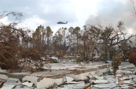
The damage and loss of life inflicted by this massive hurricane in Louisiana and Mississippi was staggering with significant effects extending into Alabama and the western Florida panhandle. This was a storm that captivated the public and media with most coverage occurring in the New Orleans area. Considering the scope of its impacts, Katrina was one of the most devastating natural disasters in United States history.
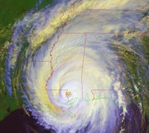
As Katrina set new minimum central pressure records while approaching the northern Gulf Coast on Sunday, August 28th, the storm made its final turn to the north as it moved toward southeastern Louisiana. Katrina was a large storm with a very distinct eye. Early on the 28th, Katrina reached a minimum central pressure of 902mb (at the peak) – ranking 7th lowest on record for all Atlantic Basin hurricanes – and rapidly intensified to a Category 5 (175mph).
Katrina then weakened to a Category 4 hurricane as it moved across the north-central Gulf and weakened further to a strong Category 3 hurricane shortly before making landfall in southeast Louisiana. The central pressure at landfall was 920mb – ranking 3rd lowest on record for a US landfalling hurricane, behind Hurricane Camille in 1969 (900mb) and the Labor Day Hurricane that struck the Florida Keys in 1935 (892mb).
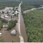
The storm continued moving north-northeast and made a second landfall over Hancock County, Mississippi (near the mouth of the Pearl River) – still Category 3. After Katrina moved inland into southern Mississippi on the afternoon of August 29th, the storm left a wake of devastation that will never be forgotten. The loss of life and property damage was heightened by breaks in the levees that separate New Orleans from Lake Pontchartrain. At least 80% of New Orleans was under floodwaters on August 31st.
STORM SURGE

Known for its storm surge, Katrina’s highest surge was found in a zone from just east of the eye near Bay St. Louis, MS east to the northern reaches of Mobile Bay. The Mobile State Docks measured the highest storm surge of 11.45 feet, while the lowest was 4.1 feet in the Santa Rosa Sound in northwest Florida. Storm surge was as high as 12-14 feet in Bayou La Batre, AL and likely close to 20 feet along the Mississippi-Alabama border.
Many homes were engulfed by Katrina’s surge in Bayou La Batre, AL. Major beach erosion occurred from Dauphin Island to east of Destin. The west end of Dauphin Island was completely underwater with most of the homes on the west end washed away. The surge in Mobile Bay led to the inundation of downtown Mobile causing the imposition of a dusk-to-dawn curfew. The Wallace Tunnel was closed due to high water from the surge. Most of the businesses on the Causeway over Mobile Bay were damaged or destroyed by the high water. An oil rig broke free and floated up Mobile Bay and became lodged underneath the Cochran-Africatown Bridge. The Mobile State Docks surge value of 11.45 feet was very close to being the highest value ever recorded. The previous record of 11.60 feet was set on July 5, 1916. [The exact location and degree of accuracy of the 1916 record surge value is unknown.]
No lives were lost due to the storm surge across Mobile and Baldwin Counties in southern Alabama. Long lead warning times were given by the NWS Offices in Mobile, AL and New Orleans, LA as to how high the surge would be. As early as two days before landfall, the NWS Office in Mobile issued a Hurricane Local Statement (at 725pm) that foretold of the historic storm surge values of 8-12 feet well east of Katrina’s center.
Storm Surge Map depicting a portion of storm surge data.
WIND
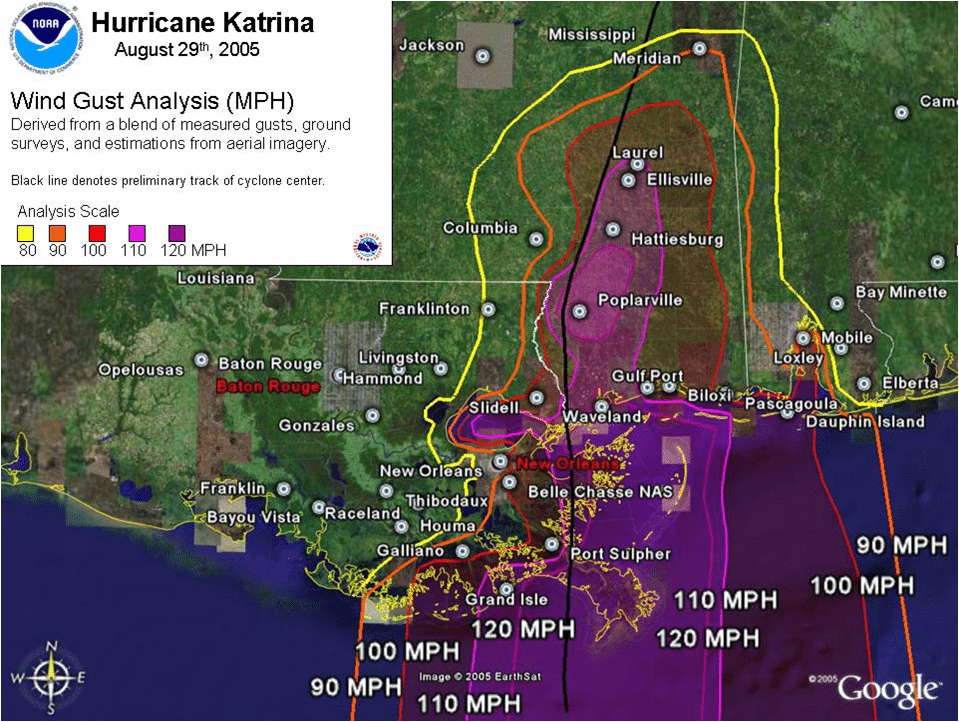
Katrina’s maximum windspeeds at landfall near Grand Isle, LA may have been as high as 140mph. As Katrina moved further north and made a second landfall along the Mississippi/Louisiana border, the NWS Doppler Radar in Mobile (KMOB) measured winds up to 132mph between 3,000-4,000 feet above ground level in the morning. It is estimated that 80-90% (approximately 104-119mph) of the maximum wind speed value actually reached the ground.
Tree damage across Stone and George Counties in south Mississippi was very similar to the damage produced by Hurricane Ivan (2004) across Atmore and Brewton in south-central Alabama.
In this velocity loop (759-859am CDT), the eye of the storm, denoted by the large white circle, is southwest of the region of maximum surface wind speeds. These measurements are the winds flowing toward KMOB radar. [Color scale where the next highest velocity values begin: gray = 104mph; brown = 109mph; dark blue = 114mph; cyan = 117mph; green >127 mph]
The wind gust analysis map shown below is courtesy of the NWS Office in Jackson, MS.
 On August 23rd, a tropical depression formed over the southeastern Bahamas, becoming Tropical Storm Katrina on August 24th as it moved into the central Bahamas. The storm continued to track west while gradually intensifying and made its initial landfall along the southeast Florida coast on August 25th as a Category 1 hurricane (80mph) on the Saffir-Simpson Hurricane Scale. After moving west across south Florida and into the very warm waters of the Gulf of Mexico, Katrina intensified rapidly and attained Category 5 status (with peak sustained winds of 175mph) for a period of time as it moved northwest on August 28th. Katrina weakened to a Category 3 before making landfall along the northern Gulf Coast, first in southeast Louisiana (sustained winds: 125mph) and then made landfall once more along the Mississippi Gulf Coast (sustained winds: 120mph). Katrina finally weakened below hurricane intensity late on August 29th over east-central Mississippi.
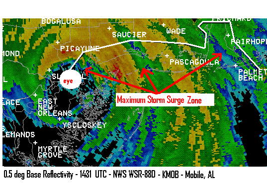
TORNADOES
The outer bands of Hurricane Katrina produced numerous tornadoes throughout the southeastern US on August 28-29, especially across southern Alabama and the northwest Florida panhandle. In total, four tornadoes rated F0 occurred in southern Alabama (2- Mobile County, 1- Baldwin County, 1- Escambia County) and five tornadoes rated F0 occurred in the northwest Florida panhandle (2- Okaloosa County, 2- Santa Rosa County, 1- Escambia County).
A majority of the tornadoes in the outerbands of Katrina were brief and on the ground for 1/2 mile to two miles. The largest tornado path occurred in Santa Rosa County near Munson, FL and was on the ground for three miles. Further inland across areas covered by the NWS Offices in Jackson, MS and Birmingham, AL, tornadoes were rated F1-F2 with slightly longer paths.
Most of the damage associated with these weak outer band tornadoes was tree and power line damage. No fatalities or injuries occurred with these tornadoes.
NOTE: The F scale was used to rate these tornadoes back in 2005. As of 2007, the NWS now uses the EF scale to rate tornadoes.
RAINFALL
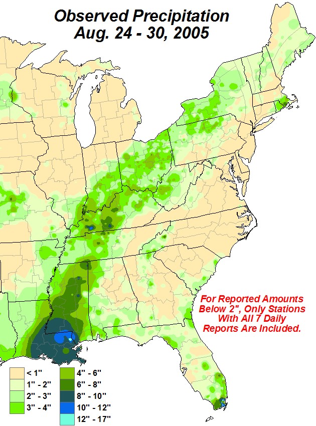
KMOB radar showed the greatest rainfall amounts occurred east of Katrina’s eye and very close to the coast. A general 5-10 inches of rain fell with isolated amounts exceeding 12 inches. Rain bands extending well east of Katrina’s eye brought isolated rainfall totals of 3-6 inches over extreme northwest Florida. Significantly lighter rainfall amounts (less than 2 inches) fell east of a line from Camden, AL to Evergreen, AL to Navarre, FL. The highest rainfall total observed in our county warning area was in Philpot, FL where 7.80 inches of rain fell in 48 hours. Flash flooding occurred throughout the day as Katrina made landfall due to the heavy rainfall.
The extent of rainfall can be seen in the map of observed precipitation for the southeastern US during Hurricane Katrina’s lifetime (August 24-30). Photo courtesy of NCEI (formerly NCDC).