
After a stormy weekend that left more than 8,000 Mississippians without power, the National Weather Service is warning that more severe weather could impact the state this week.
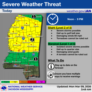
NWS Jackson has issued a Slight Risk (Level 2 of 5) for nearly half of the state Monday with cities like Jackson, Meridian, Columbus, Greenwood, Greenville, Cleveland, Clarksdale, Oxford, and Tupelo falling into the impact zone. Conditions are expected to begin around noon and go through 9 p.m.

“Severe storms capable of hail up to golf ball size and damaging wind gusts are possible over the area this afternoon and evening,” NWS Jackson warned. “Tornadoes cannot be ruled out as well.”
The northern tip of the state, from Southaven east to Corinth, along with much of the Pine Belt west toward Natchez, is under a Marginal Risk (Level 1 of 5). Conditions could include storms, hail up to a quarter size, heavy winds, and possibly a tornado.
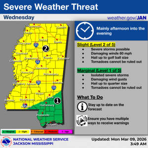
The expanded outlook from NWS shows the entirety of the state under some sort of risk for storms on Wednesday afternoon and into the evening.
Most of the state is under a Slight Risk (Level 2 of 5) while the southeast corner of the Pine Belt and the coastal region is under a Marginal Risk (Level 1 of 5).
Keep up with the latest forecast by clicking here.