
The entire state of Mississippi could see severe weather this week, according to the National Weather Service.
After heavy rainfall in some areas over the weekend, showers began redeveloping in part of the state Monday morning. The next round of severe weather is expected from Monday afternoon into early Tuesday morning.

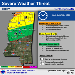
Areas stretching from the southern Delta to the Alabama state line are under a Marginal Risk (Level 1 of 5), while the rest of north Mississippi is under either a Slight Risk (Level 2) or Enhanced Risk (Level 3).
Damaging wind gusts of up to 70 miles per hour and hail ranging from quarter-size to golf-ball-size are possible. Tornadoes cannot be ruled out. The threat is expected from 3 p.m. to 1 a.m.
A brief lull is expected before the entire state is at risk of severe weather beginning Tuesday afternoon.
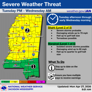
Most of central and north Mississippi are forecast to be under a Slight Risk (Level 2 of 5), while the Pine Belt and coastal regions are under a Marginal Risk (Level 1).
Potential hazards include thunderstorms, damaging winds, and hail. Tornadoes cannot be ruled out. Conditions are expected to last from Tuesday afternoon through Wednesday morning.
Additional severe weather is possible Wednesday afternoon and evening across central and southern Mississippi, though long-term forecasts are not as precise.
The threats of severe weather come as 45 Mississippi counties remain under federally designated drought conditions.
Keep up with the latest forecast here.