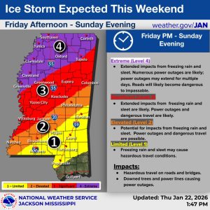
As we near closer to the weekend when Winter Storm Fern is expected to impact Mississippi, the National Weather Service has released an updated timeline on when hazardous elements will reach certain parts of the state.
NWS forecast Thursday afternoon that the first of the severe weather will hit the northernmost part of the state as early as 9 p.m. on Friday and creep southwest to Greenville. Expected conditions are currently categorized as “extreme,” meaning extended impacts could include freezing rain and sleet. Numerous power outages, some of which could extend for multiple days, are “likely.”

Early Saturday morning, still severe but slightly lesser conditions are forecast to move southward and take over much of central Mississippi. Elements such as freezing rain and sleet will keep trekking south throughout the day and into the night, reaching as far as just below Hattiesburg on Sunday morning.
The Gulf Coast should not see much of a winter mix but may experience intermittent showers, according to NWS.
NWS forecasts dangerously cold temperatures to remain into early next week. Statewide, lows will be between 10 and 20 degrees.
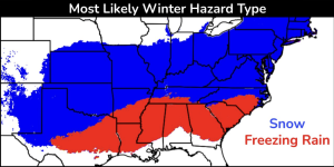
Not much snow is expected
Opposed to previous winter storms the state has faced as of late, including the infamous winter storm of February 2021, not much snow is expected in Mississippi this weekend.
NWS Jackson meteorologist Orion Jones said any snow that falls will more than likely be in the northernmost part of the state near Tennessee, but the upper Delta could have a “small chance” with a 20% chance of one-inch ice accumulation.
“At this moment, I know some models did call for snow a few days ago in the very northern reach of our area, which would be Bolivar County and Cleveland. However, that has since changed,” Jones said on Wednesday. “As far as the entire state, there may be a small chance for them to get snow just along the Tennessee border.”
Residents urged to prepare now
It’s not too late to make sure you’re as ready as possible for severe weather. The NWS uses the “four Ps” as a safety mnemonic to remind people on the best ways to prepare:
- People: Ensure family and neighbors stay warm, check on the elderly, and limit time outside.
- Pets: Bring all pets and livestock indoors or provide a warm, dry shelter with unfrozen water.
- Pipes: Insulate exposed pipes, disconnect hoses, and let indoor and outdoor faucets drop to prevent freezing and bursting.
- Plants: Cover outdoor plants with cloth or bring potted plants inside to protect them.
Jones gave some additional advice while reiterating some of what NWS offers in its safety mnemonic.
“The first thing people need to worry about is their indoor and outdoor faucets. Just have them dripping throughout this cold-weather event,” he advised. “Make sure you have batteries or a heater of some sort. If you can get a propane heater that doesn’t rely on an outlet, that would be great.
“Make sure your vehicle is fully fueled because you can use that as kind of a cell phone charger or heater when in a pinch. Make sure to have some water and canned goods on hand.”
For those who need a warm place to go during this weekend’s weather, the Mississippi Emergency Management Agency has a running list of cold-weather shelters. It can be found here.
Roadways being prepped as residents urged to stay off
Preparations through the Mississippi Department of Transportation have been underway since earlier this week. The state agency began brining roads Thursday morning in the northern part of the state. Brine is a liquid solution of salt and water applied directly to roadways to help prevent ice from sticking.
Even with those preparations, MDOT executive director Brad White encourages people to stay off the roads this weekend unless “absolutely necessary.” Crews will be on call to help clear roadways throughout the storm, but White says that is mostly with first responders and utility providers in mind.
White pointed people to MDOT’s website and mobile app for the latest updates on roadway conditions and closures.
Utility companies, cell providers readying for worst
While Jones does not believe the entire state will lose power for an extended period of time, he said power outages “are not out of the picture by any means.”
Local utility providers such as Entergy Mississippi, Tennessee Valley Authority, and Mississippi Power are readying to respond to any outages. Each are bringing in additional crews to be able to essentially work around the clock and restore power as safely and as quickly as possible.
“If we get around half an inch of ice, that begins to create a problem for us,” Entergy Mississippi President and CEO Haley Fisackerly explained. “Right now, we’re telling our people to rest up, get prepared, and get packed. Once an incident happens, we go to 16-hour workdays.”
Any significant ice storm also poses a risk for cell companies as heavy ice itself can block or bend antennas, reducing service range and leading to dropped calls and slower data.
C Spire, the country’s largest privately held wireless carrier and based in Mississippi, has been readying since the beginning of the week. Efforts have included verifying backup power by simulating commercial power loss at key sires, inspecting power connections and electrical systems, and getting mobile cell sites ready if additional coverage is needed, among other efforts.
“We’re monitoring everything in real time and working together to coordinate,” C Spire Vice President of Network Operations Charles Watson said. “We have a 24/7/365 [place] we’re staged up in and keeping a running list of impacted areas. We’ll be watching as the storm passes through.”
Keep up with the latest forecast by clicking here.