
Mississippi weather officials are warning that much of the state is under the threat of severe storms beginning Tuesday afternoon.
National Weather Service officials are forecasting a marginal threat of severe weather beginning after midnight, while the risk will be upgraded to “enhanced” Tuesday afternoon.

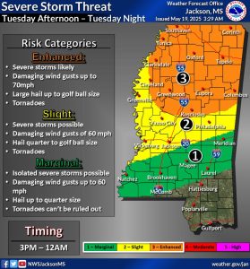
“Severe storms are likely along & northwest of the Natchez Trace corridor Tuesday afternoon into night, while possible to the southeast,” Mississippi Emergency Management Officials said Monday. “The main threats: damaging wind gusts to 70 mph, large hail up to golf ball size & tornadoes. Take your severe weather precautions.”
Stay up to date with the latest forecasts here.