
Severe weather is forecast for the majority of the southern and central portions of Mississippi later in the day, with the chance of wind gusts and tornadoes set to rise in the evening.
According to the National Weather Service in Jackson, the greatest potential for severe storms is in the southern parts of the state, especially along and below the Highway 98 corridor.

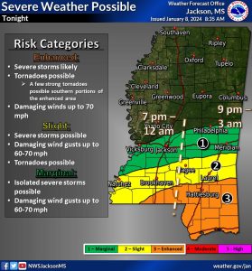
At this time, the NWS is predicting damaging winds up to 70 miles per hour and power outages starting on the coast around 7:00 p.m. before traveling north into the Pine Belt and central Mississippi. A few strong tornadoes may also appear near the coast as the storms progress into the state.
The Mississippi Emergency Management Agency (MEMA) is warning residents of a flash flooding risk with the system starting in the afternoon and going into the overnight hours.
- Six inches of fast-moving water can knock over and carry away an adult
- 12 inches of fast-moving water can carry away a car
- 18 to 24 inches of fast-moving water can carry away SUVs, vans, and trucks
7:36am CST #SPC Public Severe Weather Outlook #PWO concerning #alwx #flwx #lawx #mswx #txwx https://t.co/v0C3mGKUxV pic.twitter.com/0jXsIJweoH
— NWS Storm Prediction Center (@NWSSPC) January 8, 2024