Tropical trouble may be on the horizon for the Mississippi Gulf Coast, according to emergency management officials.
“A tropical disturbance will move over the Gulf Coast starting today and continuing through the remainder of the week,” a Wednesday announcement by the Mississippi Emergency Management Agency reads. “Some areas could see several inches of rainfall over a short period of time.”

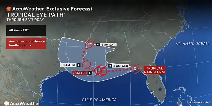
The disturbance, called Invest 93L, could eventually turn into Tropical Storm Dexter after moving through Florida and back into the Gulf. An invest is a term used by the National Hurricane Center to designate a weather system being closely monitored for potential development into a tropical cyclone.
According to Fox Weather, which has a meteorologist currently stationed in Biloxi, the system’s movement back into the Gulf means it could intensify and become more organized.
Hurricane Hunter aircraft will survey the system Wednesday afternoon when the center of circulation is expected to be over open water.
Flash flood warnings have already been issued along the Mississippi Gulf Coast as chances of precipitation move westward. The eye path rainfall could reach the central part of the state, as well. Alabama, Mississippi, and Louisiana are expecting up to seven inches of rain Wednesday through Saturday.
The Mississippi Emergency Management is encouraging residents who live in areas where there could be potential impact to take photos of valuables and larger appliance serial numbers, save copies of important documents, elevate and anchor critical utilities, clear debris from gutters to avoid water buildup, and move furniture and other valuables to a higher location such as an attic.
A tropical disturbance will move over the Gulf Coast starting today and continuing through the remainder of the week. Some areas could see several inches of rainfall over a short period of time. Here are some tips on what you can do to prepare your home before a possible flood:… pic.twitter.com/Ay4CAwkzmf
— msema (@MSEMA) July 16, 2025