
Rain started coming down in much of Mississippi on Wednesday morning with dangerous storms potentially moving in and sticking around until early Thursday.
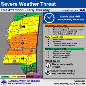
The National Weather Service has placed the entire state, apart from the immediate coastline, under a severe weather threat beginning after 4 p.m. on Wednesday.

An Enhanced Risk (Level 3 of 5) is in place for much of central Mississippi, including areas along and near the Interstate 20 corridor from Vicksburg through Jackson to Meridian. Other cities in this zone include Columbus, Kosciusko, Yahoo City, Philadelphia, Magee, and Laurel.
A Slight Risk (Level 2 of 5) covers two separate regions: a stretch of north Mississippi – including pockets of the Delta, Oxford, and Tupelo – and another area extending from Natchez to the Alabama state line, including Brookhaven, Hattiesburg, and McComb.
A Marginal Risk (Level 1 of 5) is also in place for two areas: the very northern stretch of the state – including Southaven, Tunica, and Corinth – and a small portion of the lower Pine Belt, including Poplarville.
Conditions could include severe storms, damaging winds up to 70 miles per hour, and hail ranging from quarter- to golf-ball-size. Tornadoes are possible, and localized flash flooding cannot be ruled out.
The threat of severe weather comes as 45 Mississippi counties remain under federally designated drought conditions.
Keep up with the latest forecast by clicking here.