
The Mississippi Emergency Management Agency warns that a threat of severe weather has been elevated for portions of central and south Mississippi through tonight. Be aware of flooding over roads and possible road closures.


Severe storms moved across parts of Mississippi Wednesday night causing extensive damage in its wake. Here is the latest information:

Madison County:
Several homes and businesses suffered damage. Straight-line winds of nearly 80 miles per hour and large hail have been reported. All Madison County School campuses are closed today (Wednesday, March 4, 2020). Power is out at several campuses & roadways are impassable in many areas.

The Mississippi Emergency Management Agency says residents in Madison County, impacted by the storms, are encouraged to utilize the Crisis Track Damage Assessment Tool.
Jones County:
According to the Jones County Sheriff’s Department (JCSD), deputies have been busy responding to reports of trees down, vehicle crashes, and damage caused by severe weather and hail. Two tornado warnings and a severe thunderstorm warning were issued overnight in the area. Jones County EOC 911 dispatchers have been extremely busy answering 911 calls and dispatching emergency services units and managing radio traffic. At least two JCSD vehicles have sustained hail damage.
Scott County:
Reports from the Scott County Sheriff’s Department indicates trees and light poles are down in every part of the county. Deputies, fire departs, EMS, and supervisor crews are out doing everything they can to ensure safety.
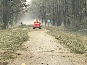
Mississippi Department of Transportation Reports:
*First Responders work to clear trees on Highway 489 near the Newton/Scott County line
*Earlier this morning, fallen trees closed multiple highways in Scott County (483 between Forkville & Ludlow, 13 between Lena & Morton, 35 between Leake/Scott Co. Line & Forest.) UPDATE: All have been reopened.
*Early this morning in Covington County, MDOT crews removed fallen trees from Highway 184.
Natchez Trace Parkway:
Due to overnight and early morning storms, the Natchez Trace Parkway is closed from milepost 114 to milepost 123.
Power Outages:
Entergy Update:
Entergy reported peak outages of approximately 15,000 statewide from the severe storms Wednesday night, with 14,000 of those in Madison County.
As of 10:30 a.m., there are just under 12,600 customers without power, primarily in Madison County where 10,223 are out due to storm damage.
Entergy is currently bringing in additional line crew resources and damage assessment resources heading to the Madison County area. Several trees are down and there are preliminary reports of several poles down. The transmission feed to the Flora substation is also out. Entergy has identified a tree on the line that they are currently working to clear. Once they can assess the damage, they will be able to get a projection on the time it will take to get all customers restored.
For the latest information on outages and any available restoration information, customers can visit the View Outages map at:
You are urged to stay away from downed power lines as they could be live. Report downed lines and outages to 1-800-9OUTAGE (800-968-8243).
Southern Pine Electric (As of 10:45 a.m.)
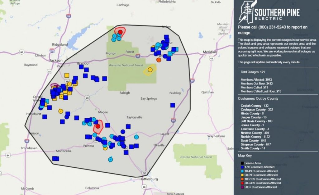
Click here to view the most up to date Southern Pine outage report.