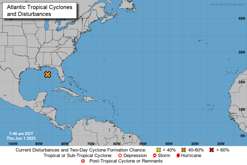
A tropical disturbance over the northeastern Gulf of Mexico has grown larger overnight, just in time for the official start of hurricane season.
According to the National Hurricane Center, a short-lived tropical depression or storm could form in the next few days, but conditions for additional development will increase by the weekend.
The Hurricane Hunters are scheduled to investigate the system later today.

Tropical Weather Outlook
NWS National Hurricane Center Miami FL
800 AM EDT Thu Jun 1 2023

For the North Atlantic...Caribbean Sea and the Gulf of Mexico:

1. Northeastern Gulf of Mexico (AL91):
Showers and thunderstorms associated with an area of low pressure
over the northeastern Gulf of Mexico have increased and become
better organized during the overnight hours. Environmental
conditions appear marginally favorable for additional development
over the next day or so, and a short-lived tropical depression or
storm could form over that time span as the system meanders over the
northeastern Gulf of Mexico. However, by this weekend environmental
conditions are forecast to become unfavorable for additional
development as the system drifts southward, likely remaining
offshore over the Gulf of Mexico. An Air Force Reserve Hurricane
Hunter aircraft is scheduled to investigate the system later today,
if necessary.

Regardless of development, locally heavy rainfall could occur over
portions of the Florida Peninsula through this weekend. Additional
information on the rainfall and flooding potential can be found in
products issued by your local National Weather Service forecast
office and Excessive Rainfall Outlooks issued by the Weather
Prediction Center.
* Formation chance through 48 hours...medium...50 percent.
* Formation chance through 7 days...medium...50 percent.


