
Mississippi has been no stranger to severe weather as of late. The worst winter storm in over three decades hit the state in late January, primarily impacting north Mississippi and pockets of the Delta. This past weekend, 12 tornadoes were confirmed in southwest Mississippi.
Another weekend of potentially rough weather is on tap, according to the National Weather Service.

NWS Jackson has issued a Marginal Risk, or Level 1 of 5, for severe weather Saturday morning and into the evening for much of the state.
“Isolated severe storms will be possible Saturday as a frontal boundary moves south across the area,” NWS Jackson warned. “Storms are possible before sunrise across northern Mississippi, progressing southward through the day.”
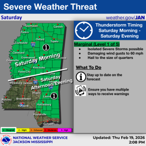
“Hail to the size of quarters will be the main threat across the north Saturday morning, with damaging winds up to 60 mph becoming an additional threat central and south in the afternoon and evening,” NWS Jackson continued.
After any potential storms, temperatures statewide are forecast to drop heading into next week. NWS Memphis, which extends into north Mississippi, is predicting Thursday’s highs in the 70s to dip into the upper 40s and lower 50s by Sunday and well into the 40s on Monday.
For example, the high for Tupelo on Monday is 45; the high for Oxford is 44; the high for Clarksdale is 44; and the high for Corinth is 42.
Temperatures are forecast to rise again as the week moves on with highs in north Mississippi climbing back into the 60s by Wednesday.